There is a plan to make a homepage that would guide through different tasks. One of Sailfish users is looking into it. In addition, maybe GPX should be added somewhere more obvious, but I am not sure where.
No (didn’t expect that the difference in the manipulated pictures wouldn’t show ).
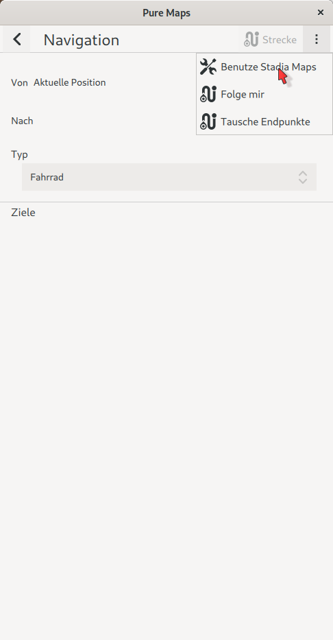
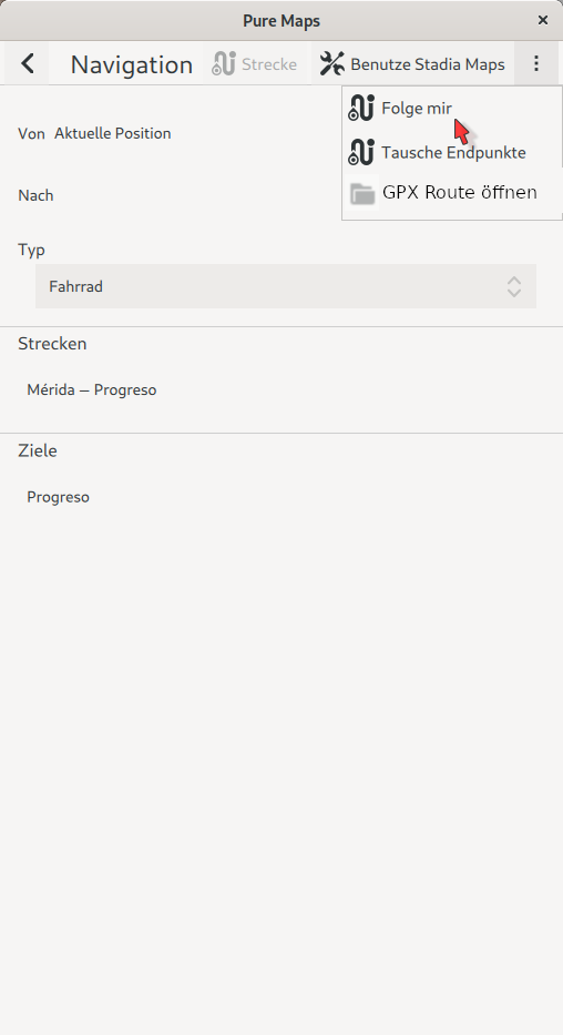
In the left picture in the area of “Strecken” the first item in the list is new: “aus Datei öffnen (GPX-Datei)”. It’s ment to open the file selection dialog to choose a gpx file.
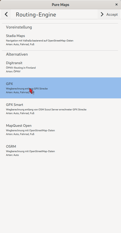
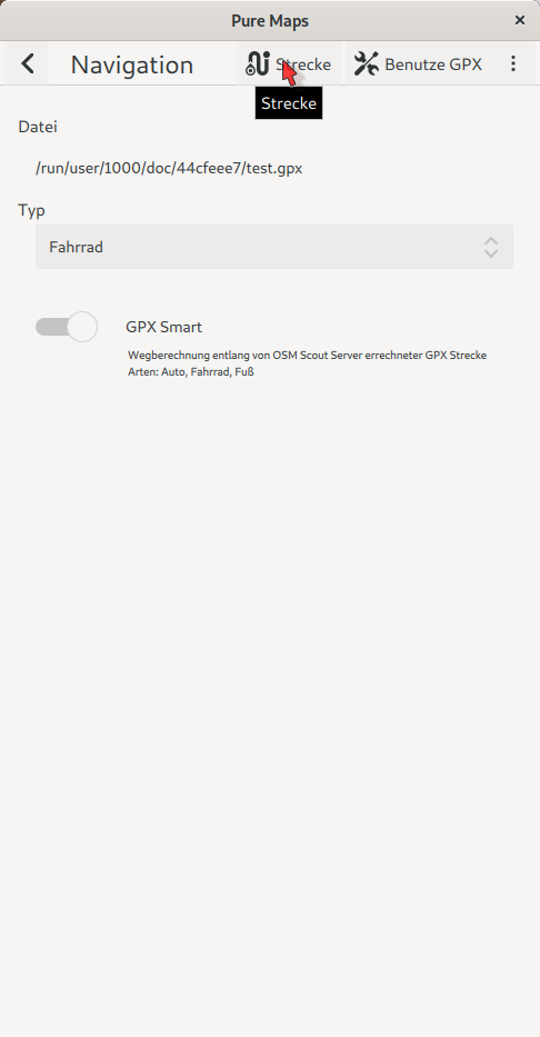
In the second picture (after opening a gpx file) the placement of the “GPX Smart” selection is new.
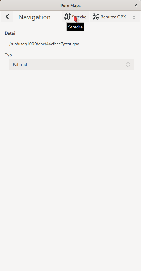
As of writing this I see that “Benutze GPX” shouldn’t be there (not necessary anymore) and there could be a button to dismiss the file. But by the logic for navigation without gpx the disabling of the route could be the same way as disabling/deleting any other route: By clicking on the head status (showing distance total and to go) for the actual route and then select in the “Anweisungen” screen “Löschen”.
Afterwards the gpx file route could be shown in the “Strecken” section of the left screen above.
Maybe we should move further discussion into an issue in your git repository?
Got around to install PureMaps and OSM Scout Server (great work, @rinigus ). Works fine.
But the planning options are not sufficient to plan a route for a roadbike ride returning to the point one left from (which is not all to bad, because it keeps the interface for the main purpose of the program clean).
For this I found brouter-web-standalone very helpful. It uses gauss.openstreetmap.de to get tiles and (didn’t find this out, yet, but suspect:) vector information for routing.
In its documentation mapsforge-tile-server is referenced as a tile server to run brouter-web without network connection. The mapsforge-tile-server project is not developed anymore.
I tried to find information how to get brouter-web to use your tile server OSM Scout Server, but didn’t get it working, yet.
brouter-web would like to request tiles via http e.g. http://localhost:6090/{z}/{x}/{y}.png . I didn’t find a way to get a tile in png format from OSM scout server so far. Further more I do not understand which data brouter requests/stores to be able to route, but that would be the next step after having brouter-web show a user interface containing an offline map.
The workflow I’m aiming at is the following
plan route in brouter-web using a web browser (already works, but not offline, yet)
get the gpx of that route (already works)
use PureMaps offline with OSM Scout Server during cycling (or whatever mode of transportation) (already works)
use the gpx in PureMaps as a route (already works, this way it is easy to have a course that ends where it starts)
Once I got this running (preferably with only one tile server, the one developed and maintained by @rinigus ), I’d like to try installing it on the pinephone and for sure - once arrived - to my Librem5.
I’m wondering whether a little proxy is needed as a converter for the data exchange between brouter-web and OSM Scout Server or if OSM Scout Server can provide the data as needed by brouter-web?
I am not sure I understand what is exactly a problem.
Re router: what is missing for you in the router? Maybe we can look into requirements and then you could check with Valhalla project what should be fixed.
Reasons for asking are simple - any additional router that you want, will lead to more data required on device. This is due to the router-specific format used to store data. For example, Valhalla, on import, already has some processing done.
If you need to get raster tiles (tiles with *png), you would have to enable raster tile support in the profile of OSM Scout Server. That’s extra data as raster tiles are generated by Mapnik. API (URL form) is described at https://github.com/rinigus/osmscout-server#raster-tiles . So, you will have to adjust brouter-web requested URL. As it was never needed, I don’t have raster tile generation from Mapbox vector tiles.
I think what @ChriChri is referring to, is that he wants to route circular routes that have the same start-end-point. Possibly, there is a need to be able to use map (raster images) and routing while offline. But I’m wondering if this is a matter of adding waypoints to achieve the same, or is there other problem using the exact same point for start and end?
Anyways, this is interesting use-case and descriptions/documentation/guide for both, user howto on planning a circular route (if it’s not straight forward or can be done in a special way) and how to set up offline maps and routing, would be a nice read. If there already is a good one, link here, or maybe formulate one now based on this…?
OK, I see. same start-end points would require support for waypoints. That is planned to be added to Pure Maps and is supported by routers already. I just have to get to it by rewriting routing support (want to change few things and address multiple issues via it)
Thanks for the information and hint to look into Valhalla which is quiet interesting reading.
For Valhalla I didn’t find any information how to use elevation in route cost calculation which is a major feature of brouter. Furthermore brouter makes it very simple for users to adjust the route cost calculation to their needs and there are a lot of profiles around. brouter can calculate the cost of a path for a rider from the riders power and weight.
As I understood this all can be added to Valhallas route cost calculation also, but it is from what I read not possible by just changing a simple text file (no programming skill needed).
Another argument which makes me believe that planning routes for use in PureMaps using brouter-web is quiet a good idea is that the interface is already optimized to do so.
There is no doubt that having all the features directly accessible in PureMaps would be great, but I guess it would take really some time to implement whats missing.
I agree that it would be a great advantage to have the map data only once (in one format) on the device, but from the information you provided that seems to be impossible whithout having some major changes in one of the projects.
Re elevation: Valhalla actually does have elevation data that it can consider. I never packaged it for offline as it was rather big.
Sounds like brouter is targeted router and probably can currently provide a better routes for you. Note that you could also implement router interface between brouter <–> Pure Maps. Assuming that brouter does have some HTTP API. Current routers and README on how to make a new one are at https://github.com/rinigus/pure-maps/tree/master/routers
If you want / have to go with GPX approach, for offline tiles, you could still use mapnik raster tiles by osm scout server.
To be honest: I really don’t know since I didn’t compare much to Valhalla routing.
I agree with you that it’d be best to push one solution to the point of being usable for sports (the idea of getting back to where you started after a course applies to running most times also…).
I guess brouter could be integrated into PureMaps since it offers a http api. If PureMaps would offer waypoints to plan routes it would (I guess) sufficiently replace my mentioned usage of osmand.
Maybe all this could be done with Valhalla, also. Maybe I’ll get around to look into it.
For the moment I’ve got running brouter-web as a ui for planning using OSM Scout Server (thanks for helping with the configuration of providing raster images!) and the resulting gpx route can be used in PureMaps for navigation.
This solution can evolve into a better direction in the future and it works now - at least on my desktop.
I’ll play a bit around with it and will try to set it up on my Pinephone (or if delivered until then the Librem5).
Just hopping in - perhaps a wee bit out of focus, but to give a first-hand-idea regarding that topic:
For more than 10 years i provided a free online-route-planning-service that gave worldwide coverage. I remember a new little company turning up that provided paid osm-map-tiles. I offered them to do a stress-test on their infrastructure by using their tiles as primary-layer. The test lasted only some days, but generated an unbelievable amount of traffic on their systems.
To come to the point: Giving world-wide map- and routing-coverage consumes quiet a lot of ressources on the provider-side. If not run locally, i’d guess such an infrastructure is not easily run for free for a longer time. So please bear in mind that developers/providers might require support to keep the wheel rolling.
We are doing a survey of mobile GNU/Linux users to pick a navigation app that we should support through bounties to get a good navigation experience soon. Please vote and pick your favorite app at Pick and fund a maps app

 ).
). I guess I’ll not find the time soon to work that out.
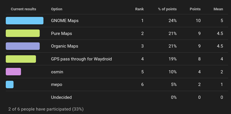