Librem 5 GPS/Location Tracking

It gives a bunch of data like this:

$GNGSA,A,1,,,,,,,,,,,,,99.0,99.0,99.0*1E
$GPGSV,3,1,11,01,77,077,,07,65,227,,30,52,292,,21,50,043,*75
$GPGSV,3,2,11,17,32,277,,22,28,121,,14,27,322,,03,21,131,*75
$GPGSV,3,3,11,08,20,048,,19,10,257,,09,06,203,,,,,*48
$GLGSV,1,1,02,87,41,012,,81,27,233,,,,,,,,,*60
$GPGLL,2256.33128,N,11351.74301,E,144745.000,V,N*48
$PSTMCPU,25.46,-1,49*4A
$GPRMC,144746.000,V,2256.33128,N,11351.74301,E,0.0,0.0,281121,,,N*75
$GPGGA,144746.000,2256.33128,N,11351.74301,E,0,00,99.0,031.00,M,0.0,M,,*65
$GPVTG,0.0,T,,M,0.0,N,0.0,K,N*02
The GSV lines are lacking the value which I inserted as ss:

$GPGSV,3,1,11,01,77,077,ss,07,65,227,ss,30,52,292,ss,21,50,043,*

which should be a two digit value between 00 and 99 and measures the signal/noise ratio. Without having them above 20++ for some minutes for some satellites, there will not be a fix.

@guru is correct. If that dump is from inside that is expected, please try the dump outside > 12 minutes.

The fact that the module is showing satellites is good, either it means the module has downloaded at least a partial almanac or you’ve uploaded an almanac to the module.

15 minutes outside, here’s a tail of the GPPSV:

$GPGSV,3,3,11,02,12,249,,01,11,042,,09,06,145,,,,,*4F
$GPGSV,3,1,11,14,81,157,,06,51,273,,17,49,008,,19,39,331,*70
$GPGSV,3,2,11,03,27,049,,22,20,044,,30,19,199,,11,18,244,*70
$GPGSV,3,3,11,02,12,249,,01,11,042,,09,06,145,,,,,*4F
$GPGSV,3,1,11,14,81,157,,06,51,273,,17,49,008,,19,39,331,*70
$GPGSV,3,2,11,03,27,049,,22,20,044,,30,19,199,,11,18,244,*70
$GPGSV,3,3,11,02,12,249,,01,11,042,,09,06,145,,,,,*4F
$GPGSV,3,1,11,14,81,157,,06,51,273,,17,49,008,,19,39,331,*70
$GPGSV,3,2,11,03,27,049,,22,20,044,,30,19,199,,11,18,244,*70
$GPGSV,3,3,11,02,12,249,,01,11,042,,09,06,145,,,,,*4F

It still has a few blank values in the commas. Does this mean the GPS is not working correctly?

Was in a open area and there wasn’t a cloud in the sky

I do not see any ss value between the commas.

There’s no SNR values in there so it’s not seeing any satellites. I’d contact support@puri.sm .

1 Like

I tried to get a fix on my L5, but I also do not see any ss values when I do:
socat unix-client:/var/run/gnss_share.sock - | grep -ai --line-buffered gsv

Here some output that I see:

$GPGSV,3,1,09,16,64,308,,27,48,175,,26,47,021,,31,36,071,*73
$GPGSV,3,2,09,04,35,320,,08,22,197,,03,23,258,,22,19,235,*74
$GPGSV,3,3,09,32,15,147,,,,,,,,,,,,,*47
$GLGSV,1,1,03,87,28,117,,86,16,051,,88,13,158,,,,,*57

I had the L5 outside for roughly 30 minutes, and for more than half a day close to the a window at the top of my house. The sky is cloudy nowadays here in the Netherlands. When the L5 was outside the number of satellites increased IIRC.

In the /var/cache/gnss_share/ directory, I only have a recent almanac.txt that I did not put there myself. It seems to update every day.

Should there also automatically appear an ephemeris.txt ?

# ls -l /var/cache/gnss_share/  
total 8  
-rw-r--r-- 1 root root 4464 Nov 30 08:57 almanac.txt

@steve: Did you contact Purism support? If so, what was their response?

My GPS does work (it takes some time to get a fix, but then I can use pure maps to navigate) but for me no ephemeris.txt file is created (while almanac is)

1 Like

I own two L5 devices, one does not see ss values and does not get a fix. The other, which sees ss values gets a fix even with cloudy sky in less than 2 minutes. It has also the two files ephemeris.txt and almanac.txt.

There are statements here in the forum that the reason could be a bad grounded antenna of the GNSS receiver chip. View this post: Librem 5 GPS/Location Tracking

3 Likes

Mm interesting… I’m using gnss_share --version : 0.3, is yours the same?

edit: found updates on the git repo, I’ll try to rebuild it

apt search gnss gives

...
gnss-share/byzantium, now 0.3-0pureos2 all [installed]
An app for sharing GNSS location data

Ok it seems like I built it myself, I just installed it from the repo (when it was still written in python, now it has been rewritten in go). I see that the service is automatically enabled, I’ll wait some time to see if the file appears

Does pure maps report the correct speed for you? Mine always report 4km/h

I’m using the app Maps and was told that this uses geoclue and this in turn not GPS. What is ‘pure maps’?

apt search pure-maps

It’s a navigation program, I think it’s using geoclue (which with gnss-share should use GPS)

geoclue does not interface directly to the gnss device. gnss-share will feed gnss coordinates to geoclue

Both Maps and pure-maps will get their data from geoclue.

I have, no response yet,
I’ll let you know when I get something.

1 Like

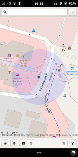
I have here a screenshot of Maps. The L5 have had a fix in this moment and my real position was in front of the building number 14 where a small cocktail glass is shown. Maps showed my position some 20 meters more to the east.

The accuracy of that fix looks more like a wifi AP fix than a GNSS fix. A GNSS fix should be a 3M circle or less.

2 Likes

I did:

# gnss_share --version
warning: trio-serial not found, some drivers may not work correctly
version: 0.3

Is the warning trio-serial not found, some drivers may not work correctly relevant?