Not on the librem5. If you’re using it with a serial source then it will matter ( it’s a different mode for collecting an almanac on a host )
Yes, it does not use GNSS, as explained here Librem 5 GPS/Location Tracking
I recommend editing /etc/geoclue/geoclue.conf to disable use of WiFi. Apart from use of WiFi being a privacy fail, it will make any GNSS troubleshooting more confusing.
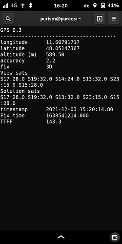
It took really long time for my Librem 5 to recognize that it is not in China and locate itself to Prague. I am not sure how much helped running gnss_test which resets satellites in view. Before that it seem that the most satellites in view has been these expected at given time to be at China sky. After reset by gnss_test I have reached about 12 satellites contacted with signal/noise in range from 8 to 28. But engine tried at max three for solution sats and each time dropped back to only one after each attempt.
I have left the Librem 5 for about two hours at the company building roof above our office where is perfect sky 360 view. Then GPS caught finally. It recognized many satellites, 18 or more, so GPS, Galileo etc… But signal/noise ratio was in range up to 30 for all satellites.
Please, can others report theirs signal/noise ratios? I would like to know if the low values are common or if they can be result of the reported grounding problem and adjustment can help in the future.
What is gnss_test and how is it accessed to reset?
See above: Librem 5 GPS/Location Tracking - #53 by guru and subsequent few posts.
In a minute or two outside the distinct SNR values that I saw were 14, 15, 19, 22, 33, 35, 36, 37 i.e. nothing higher than 37. The lower values were achieved as I retreated to the house i.e. sky view progressively blocked by house; the higher values were achieved standing outside with a fairly good sky view.
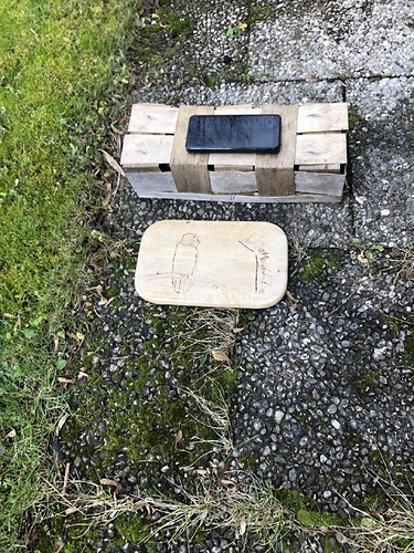
Today I played around a bit to investigate the GNSS GPS fix problem. See the attached photo:
It’s in my garden below open sky.
- When I put the L5 on the small basket of 10cm high, it gets a fix with the test pgm
gnss_test.pyin a few seconds. - When I put it down on the small board next to the basket, it looses the fix and restarting the tool, it will never get one.
- Same is true (no fix) when I put the L5 on a normal table ~1m high (near to the place with the basket)
The problem seems to be depending on the distance of the antenna to ground. I’m not an expert in high frequency transmission and receivers, but what else could it be?
Looks like a bad earthing: 10cm as 1/2 lambda is ~1.5Ghz. This is very close to the frequency of the L1 band of GPS. The 10cm gives a good virtual earthing point.
OK, if that’s the direction we are going  , I will clarify that while measuring the SNR values as reported above, I was at all times holding the phone - and making no effort to keep it a consistent distance from the ground.
When you keep the phone in your hand, you are a sort of (imperfect) capacity earthing. It can even make a difference between standing on both or only one leg  . (at one leg only half the capacity)
I have had yesterday evening the same experience: keeping the phone in the hand in around 1,5m high and close to my body, let it see satellites too. The weather was bad in the evening (cloudy and snowing) and I want to do the experiment again with clear sky.
Today we have had open sky and with the phone in my hand I’ve got this fix (this is not my house, but in town).
One question about the gnss_share files:
purism@pureos:~$ ls -l /var/cache/gnss_share/
total 12
-rw-r--r-- 1 root root 4359 Dec  3 15:08 almanac.txt
-rw-r--r-- 1 root root 1050 Nov 27 23:20 ephemeris.txt
Why the file almanac.txt was updated during this?
So which do you recommend for optimal GPS performance, standing on one leg or two?
This is tricky, it depends a lot on the shoe size and quality. If your GPS is not already working properly my suggestion is to try it out in open air .. ![]()
![]()
(I’m still waiting for my L5 and regret not being able to check this myself ![]() ).
).
If someone wants to investigate this in serio, here you can fetch the hardware manual of the chip and where and how it’s antenna should be located:
I don’t exactly know but these files need to be updated periodically.
i let it run for 8h (problem here is that the battery doesnt last that long, so it was inside under a roof window).
mine shows alot of satellites but at most a ss for 3. values are mostly below 10, the largest i saw was 17.
i found that tool quite buggy (and implemented my own script for that duty), i would expect that both files are saved on shutdown of gnss_share. anyway the data from those files should speed up the tff (time t first fix) because that data isnt read from the satellites which takes up to 20 minutes once a sat is “visible”.
Which tool and what are the bugs? Can you share your script?
Could you try the same experiment(s) by having the phone turned display-side down?
This would give a better indicator if it is indeed a ground plane problem due to antenna construction, or mainly a line-of-sight issue due to the characteristic pattern of the antenna.
Another experiment to try would be to figure out if there might be RF interference due to the other radios, which could be easily tested by turning the radios off (Bluetooth, WiFi, and Cellular).
i always do testing with display down.
today i added rfkill to all radio emission of the device to my script (which means it switches off wifi and disables network-access this way).
The script i implemented is this:
start in a terminal as root using a small font ![]() - the console works best. it uses curses to just display the status of the gps module, the sats seen, the time, the location if available.
- the console works best. it uses curses to just display the status of the gps module, the sats seen, the time, the location if available.

